TET_PL-01_20220823
- Distance: 1,070.4 Km
- Elevation gain: 5,097 m
- Maximum elevation: 342 m
- Elevation loss: 4,976 m
- Minimum elevation: 104 m
Interactive map
GPS track profile
About this GPS track
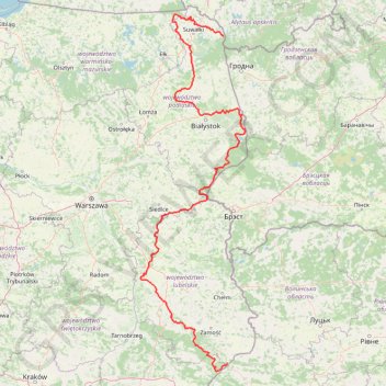
Name: TET_PL-01_20220823 GPS track, route, trail
Start: Wigrańce, gmina Sejny, Sejny County, Podlaskie Voivodeship, Poland (54.06343 23.50056)
Coordinates: 50.19146 21.93294 54.31062 23.90840
Topography: Sejny County topographic map
Other GPS tracks
Click on a GPS track to view route, its statistics and profile.
Tour d'Europe
France > Bretagne > Finistère > Concarneau > Landan Creis
Distance: 7,132.9 Km • Elevation gain: 44,603 m • Maximum elevation: 2,433 m
TET-Belarus-230614
Bélarus > Voblast de Brest > Іванаўскі раён > Махроўскі сельскі Савет
Distance: 716.7 Km • Elevation gain: 2,014 m • Maximum elevation: 202 m