GPS tracks, routes, trails, hikes

GPS tracks visualization and sharing, free and without registration.

Import a GPX file

The Granite Island Run

Granite Island Recreation Park. #Run #Loop #Granite

  • Distance: 5.4 Km
  • Elevation gain: 118 m
  • Maximum elevation: 32 m
  • Elevation loss: 115 m
  • Minimum elevation: 0 m

Interactive map

GPS track profile

About this GPS track

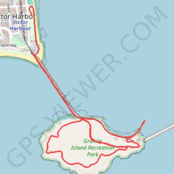
Name: The Granite Island Run GPS track, route, trail.
Start: Flinders Parade, Victor Harbor, City of Victor Harbor, South Australia, 5211, Australia (-35.55452 138.62518)
End: Victor Harbor Horsedrawn Tram, Granite Island Road, Victor Harbor, City of Victor Harbor, South Australia, 5211, Australia (-35.55732 138.62512)
Coordinates: -35.56585 138.62493 -35.55385 138.63553

Other GPS tracks

The Granite Island Run

Australia > South Australia > City of Victor Harbor > Victor Harbor

Granite Island Recreation Park. #Run #Loop #Granite

Distance: 5.7 Km - Elevation gain: 113 m - Maximum elevation: 31 m - Coordinates: -35.56588 138.62495 -35.55379 138.63551

Start: Flinders Parade, Victor Harbor, City of Victor Harbor, South Australia, 5211, Australia (-35.55454 138.62513)

End: Victor Harbor Horsedrawn Tram, Granite Island Road, Victor Harbor, City of Victor Harbor, South Australia, 5211, Australia (-35.55739 138.62526)