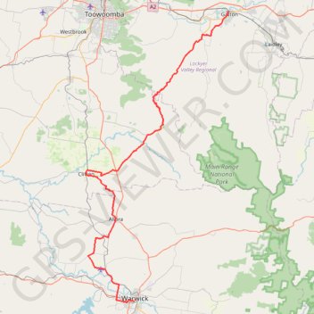
Import a GPX file

Warwick - Gatton

#Bike

  • Distance: 125.3 Km
  • Elevation gain: 812 m
  • Maximum elevation: 582 m
  • Elevation loss: 1,174 m
  • Minimum elevation: 107 m

Interactive map

GPS track profile

About this GPS track

Other GPS tracks

Click on a GPS track to view route, its statistics and profile.

Glen Rock State Forest - Table Top

Australia > Queensland

#MTB #GlenRock

Distance: 24.5 Km • Elevation gain: 679 m • Maximum elevation: 796 m

Glen Rock State Forest

Australia > Queensland

#MTB #GlenRock

Distance: 38.4 Km • Elevation gain: 383 m • Maximum elevation: 1,048 m

Tannymorel - Bald Mountain

Australia > Queensland

Gambubal State Forest. Main Range National Park. #MTB #Loop #Gambubal #MainRange

Distance: 59.1 Km • Elevation gain: 1,460 m • Maximum elevation: 1,194 m

Goomburra - Gatton

Australia > Queensland

Main Range National Park. #MTB #MainRange

Distance: 76.4 Km • Elevation gain: 1,173 m • Maximum elevation: 974 m

Killarney to Warwick via Tannymorel

Australia > Queensland

#MTB #Loop

Distance: 77.0 Km • Elevation gain: 855 m • Maximum elevation: 668 m

Goomburra - Mount Marshall - Pratten

Australia > Queensland > Goomburra

#MTB #Loop #Marshall

Distance: 89.2 Km • Elevation gain: 749 m • Maximum elevation: 614 m

Glen Rock Bottom Yards Loop Track

Australia > Queensland

Glen Rock State Forest. #MTB #Loop #GlenRock

Distance: 19.0 Km • Elevation gain: 828 m • Maximum elevation: 882 m