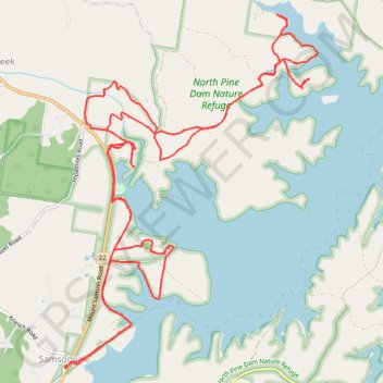
Kobble Creek - Lake Samsonvale
North Pine Dam Nature Reserve. #MTB #Loop #NorthPine #Kobble #Samsonvale
- Distance: 24.1 Km
- Elevation gain: 292 m
- Maximum elevation: 75 m
- Elevation loss: 292 m
- Minimum elevation: 39 m
Interactive map
GPS track profile
About this GPS track
Name: Kobble Creek - Lake Samsonvale GPS track, route, trail
Coordinates: -27.28246 152.84522 -27.24080 152.87870
Topography: Queensland topographic map
Other GPS tracks
Click on a GPS track to view route, its statistics and profile.