Milanesia Gate - Moonlight Head
Interactive map
GPS track profile
About this GPS track
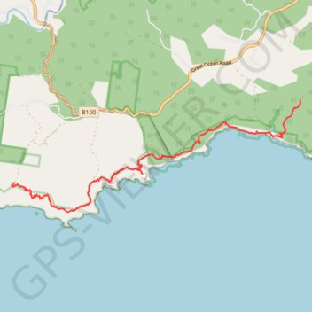
Name: Milanesia Gate - Moonlight Head GPS track, route, trail
Start: Melanesia Track, Yuulong, Shire of Colac Otway, Victoria, Australia (-38.74412 143.32297)
End: Great Ocean Walk, Wattle Hill, Shire of Corangamite, Victoria, Australia (-38.76234 143.24216)
Coordinates: -38.76877 143.24153 -38.74412 143.32303
Topography: Victoria topographic map
Other GPS tracks
Click on a GPS track to view route, its statistics and profile.
Great Ocean Walk - Milanesia Track - The Gables
Great Otway National Park. #Hike #GreatOtway
Distance: 15.9 Km • Elevation gain: 752 m • Maximum elevation: 166 m