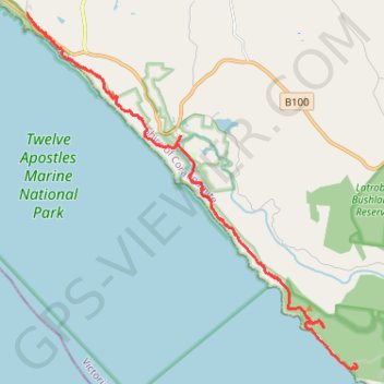
Wreck Beach - Twelve Apostles
Twelve Apostles Marine National Park. #Hike #TwelveApostles
- Distance: 19.2 Km
- Elevation gain: 471 m
- Maximum elevation: 98 m
- Elevation loss: 492 m
- Minimum elevation: -1 m
Interactive map
GPS track profile
About this GPS track
Name: Wreck Beach - Twelve Apostles GPS track, route, trail
Start: Wreck Beach Track, Gellibrand Lower, Shire of Corangamite, Victoria, Australia (-38.75351 143.21503)
End: Great Ocean Walk, Princetown, Shire of Corangamite, Victoria, 3269, Australia (-38.66219 143.10492)
Coordinates: -38.75508 143.10492 -38.66219 143.21555
Topography: Victoria topographic map