Sophia Doyle Reserve
#Hike #Loop #SophiaDoyle #Sydney
- Distance: 6.8 Km
- Elevation gain: 52 m
- Maximum elevation: 111 m
- Elevation loss: 76 m
- Minimum elevation: 51 m
Interactive map
GPS track profile
About this GPS track
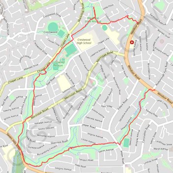
Name: Sophia Doyle Reserve GPS track, route, trail
Coordinates: -33.75999 150.96488 -33.73917 150.98641
Topography: Sydney topographic map
Other GPS tracks
Click on a GPS track to view route, its statistics and profile.
Perth to Sydney
Australie > Australie occidentale > City of Belmont
Distance: 3,801.3 Km • Elevation gain: 14,558 m • Maximum elevation: 1,159 m