Ferny Forest Loop - Ewan Maddock Dam
#Hike #Loop #Ferny #EwanMaddock
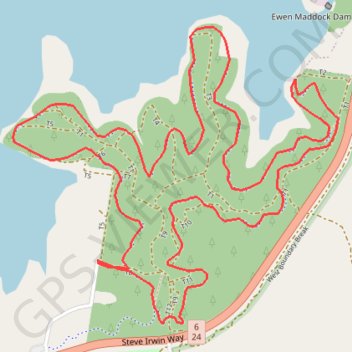
- Distance: 8.9 Km
- Elevation gain: 108 m
- Maximum elevation: 51 m
- Elevation loss: 108 m
- Minimum elevation: 21 m
Interactive map
GPS track profile
About this GPS track
Name: Ferny Forest Loop - Ewan Maddock Dam GPS track, route, trail
Start: T8, Landsborough, Sunshine Coast Regional, Queensland, 4550, Australia (-26.79140 152.99851)
End: T8, Landsborough, Sunshine Coast Regional, Queensland, 4550, Australia (-26.79128 152.99851)
Coordinates: -26.79419 152.99416 -26.78059 153.01085
Topography: Sunshine Coast Regional topographic map
Other GPS tracks
Click on a GPS track to view route, its statistics and profile.
Ewen Maddock Dam Main Track
Australia > Queensland > Sunshine Coast Regional
Distance: 8.0 Km • Elevation gain: 103 m • Maximum elevation: 46 m
Currimundi - Ewen Maddock Dam - Beerburrum
Australia > Queensland > Sunshine Coast Regional
Distance: 54.8 Km • Elevation gain: 445 m • Maximum elevation: 47 m