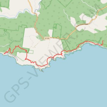
Great Ocean Walk - Milanesia Track - The Gables
Great Otway National Park. #Hike #GreatOtway
- Distance: 15.9 Km
- Elevation gain: 752 m
- Maximum elevation: 166 m
- Elevation loss: 760 m
- Minimum elevation: 6 m
Interactive map
GPS track profile
About this GPS track
Name: Great Ocean Walk - Milanesia Track - The Gables GPS track, route, trail
Start: Melanesia Track, Yuulong, Shire of Colac Otway, Victoria, Australia (-38.74844 143.31877)
End: The Gable Track, Gellibrand Lower, Shire of Corangamite, Victoria, Australia (-38.75696 143.22321)
Coordinates: -38.76879 143.22049 -38.74844 143.31886
Topography: Victoria topographic map
Other GPS tracks
Click on a GPS track to view route, its statistics and profile.