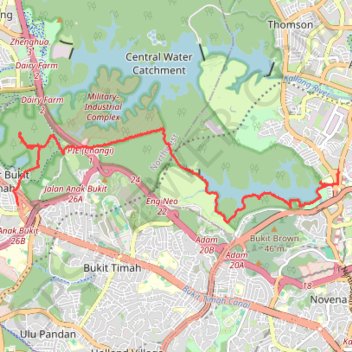
Bukit Timah Hill - MacRitchie Reservoir
#Hike
- Distance: 14.8 Km
- Elevation gain: 290 m
- Maximum elevation: 167 m
- Elevation loss: 304 m
- Minimum elevation: 11 m
Interactive map
GPS track profile
About this GPS track
Name: Bukit Timah Hill - MacRitchie Reservoir GPS track, route, trail
End: Marymount, 60, Marymount Road, Bishan, Singapore, Central, 573993, Singapore (1.34882 103.83914)
Coordinates: 1.33835 103.77457 1.35705 103.83921
Other GPS tracks
Click on a GPS track to view route, its statistics and profile.
The Green Corridor - Singapore
Singapore > Northwest > Singapore
#Hike
Distance: 22.3 Km • Elevation gain: 167 m • Maximum elevation: 44 m
Directions from Duck Tour Ramp to Marina Boulevard, Singapore
Singapore > Central > Singapore
Distance: 105.3 Km • Elevation gain: 812 m • Maximum elevation: 51 m
Kualanamu International Airport to Jakarta, Indonesia
Indonésie > Sumatra du Nord > Deli Serdang > Beringin
Distance: 1,809.2 Km • Elevation gain: 10,977 m • Maximum elevation: 125 m