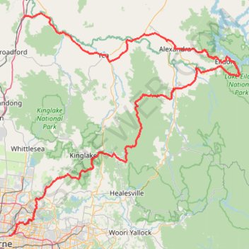
Tallarook - Eildon - Hurstbridge
#Bike
- Distance: 278.8 Km
- Elevation gain: 4,897 m
- Maximum elevation: 868 m
- Elevation loss: 5,055 m
- Minimum elevation: 13 m
Interactive map
GPS track profile
About this GPS track
Name: Tallarook - Eildon - Hurstbridge GPS track, route, trail
Start: Railway Place, Tallarook, Shire of Mitchell, Victoria, Australia (-37.09301 145.10319)
Coordinates: -37.79054 145.04384 -37.07968 145.97137
Topography: Victoria topographic map
Other GPS tracks
Click on a GPS track to view route, its statistics and profile.
Lilydale - Warburton Rail Trail
Australia > Victoria > Melbourne
#MTB
Distance: 38.1 Km • Elevation gain: 452 m • Maximum elevation: 231 m
Elgar Park to Hays Paddock including Bolin Bolin Trail
Australia > Victoria > Melbourne
Distance: 18.0 Km • Elevation gain: 116 m • Maximum elevation: 58 m
Mount Lofty Loop
Australia > Victoria > Melbourne
Yarra River. Warrandyte State Park. #Hike #Loop #Warrandyte
Distance: 5.0 Km • Elevation gain: 130 m • Maximum elevation: 121 m
Wilhelmina Falls
Murrindindi River Natural Features and Scenic Reserve. #Hike #Loop #Murrindindi
Distance: 12.6 Km • Elevation gain: 533 m • Maximum elevation: 673 m
Pound Bend Loop
Australia > Victoria > Melbourne
Warrandyte State Park. Yarra River. #Hike #Loop #Warrandyte
Distance: 6.5 Km • Elevation gain: 104 m • Maximum elevation: 84 m
The cathedral and the jawbones
Australia > Victoria > Rubicon
Distance: 12.6 Km • Elevation gain: 632 m • Maximum elevation: 817 m
Wandong loop
Australia > Victoria > Wandong
Distance: 11.2 Km • Elevation gain: 427 m • Maximum elevation: 473 m
Tallarook - Granite
Australia > Victoria > Tallarook
Great Victorian Rail Trail. #Bike
Distance: 14.8 Km • Elevation gain: 138 m • Maximum elevation: 185 m
Cathedral Range - Neds Peak
Australia > Victoria > Rubicon
Distance: 5.5 Km • Elevation gain: 447 m • Maximum elevation: 747 m
Alexandra - Cathkin - Molesworth
Australia > Victoria > Alexandra
#Bike
Distance: 19.7 Km • Elevation gain: 197 m • Maximum elevation: 288 m
Marysville Loop
Steavensons Falls Natural Features and Scenic Reserve. #Hike #Loop #Steavensons
Distance: 13.6 Km • Elevation gain: 588 m • Maximum elevation: 837 m
Molesworth - Yea
Australia > Victoria > Molesworth
Great Victorian Rail Trail. #Bike
Distance: 17.8 Km • Elevation gain: 189 m • Maximum elevation: 303 m
Yea - Granite
Great Victorian Rail Trail. #Bike
Distance: 24.6 Km • Elevation gain: 257 m • Maximum elevation: 220 m