Lakes Entrance - Lake Tyers State Park - Marlo
Interactive map
GPS track profile
About this GPS track
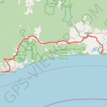
Name: Lakes Entrance - Lake Tyers State Park - Marlo GPS track, route, trail
End: Old Marlo Road, Marlo, Shire of East Gippsland, Victoria, Australia (-37.78079 148.53503)
Coordinates: -37.88107 147.97299 -37.71259 148.53970
Topography: Victoria topographic map
Other GPS tracks
Click on a GPS track to view route, its statistics and profile.
Bairnsdale - Lakes Entrance
Australia > Victoria > Bairnsdale
#Bike
Distance: 38.4 Km • Elevation gain: 318 m • Maximum elevation: 91 m