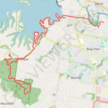
Lake Samsonvale - Clear Mountain Conservation Park
#MTB #Samsonvale #Clear
- Distance: 24.7 Km
- Elevation gain: 446 m
- Maximum elevation: 121 m
- Elevation loss: 408 m
- Minimum elevation: 3 m
Interactive map
GPS track profile
About this GPS track
Name: Lake Samsonvale - Clear Mountain Conservation Park GPS track, route, trail
Coordinates: -27.32067 152.90028 -27.27076 152.96953
Topography: Queensland topographic map
Other GPS tracks
Click on a GPS track to view route, its statistics and profile.