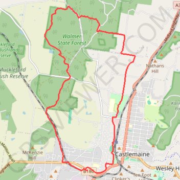
Goldfields Track - Castlemaine circuit
#MTB #Loop #Goldfields #Castlemaine
- Distance: 16.8 Km
- Elevation gain: 178 m
- Maximum elevation: 382 m
- Elevation loss: 178 m
- Minimum elevation: 272 m
Interactive map
GPS track profile
About this GPS track
Name: Goldfields Track - Castlemaine circuit GPS track, route, trail
Coordinates: -37.07216 144.18751 -37.02265 144.22111
Topography: Victoria topographic map
Other GPS tracks
Click on a GPS track to view route, its statistics and profile.
Maldon- Castlemaine Rail Trail
Distance: 16.9 Km • Elevation gain: 139 m • Maximum elevation: 360 m