GPS tracks, routes, trails, hikes

GPS tracks visualization and sharing, free and without registration.

Import a GPX file

Centennial Park - Sydney

#Bike #Centennial #Sydney
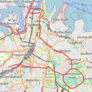
  • Distance: 29.5 Km
  • Elevation gain: 353 m
  • Maximum elevation: 75 m
  • Elevation loss: 350 m
  • Minimum elevation: 28 m

Interactive map

GPS track profile

About this GPS track

Name: Centennial Park - Sydney GPS track, route, trail.
Start: Carriageworks, 245, Wilson Street, Eveleigh, Sydney, Council of the City of Sydney, New South Wales, 2015, Australia (-33.89338 151.19141)
End: 88, Cumberland Street, Dawes Point, Sydney, Council of the City of Sydney, New South Wales, 2000, Australia (-33.85820 151.20750)
Coordinates: -33.90480 151.19141 -33.85820 151.24119

Other GPS tracks

Sydney

Australia > New South Wales > Sydney

#Hike #Loop #Sydney

Distance: 14.8 Km - Elevation gain: 464 m - Maximum elevation: 96 m - Coordinates: -33.87687 151.20258 -33.85366 151.21697

Start: The Rocks, Sydney, Council of the City of Sydney, New South Wales, 2000, Australia (-33.86110 151.20967)

End: Sydney, Council of the City of Sydney, New South Wales, 2000, Australia (-33.86114 151.21021)

Royal Botanic Garden

Australie > Nouvelle Galles du Sud > Sydney

Distance: 1.2 Km - Elevation gain: 17 m - Maximum elevation: 23 m - Total time: 21 m 54 s - Date: 01/01/10 - Coordinates: -33.86536 151.21524 -33.86195 151.21876

Start: Royal Botanic Garden, Mrs Macquaries Road, Sydney, Council of the City of Sydney, Nouvelle Galles du Sud, 2000, Australie (-33.86195 151.21537)

Sydney Sightseer

Australia > New South Wales > Sydney

#Bike #Loop #Sydney

Distance: 52.4 Km - Elevation gain: 881 m - Maximum elevation: 95 m - Coordinates: -33.90670 151.17565 -33.83946 151.28690

Start: Jubilee Oval, Victoria Road, Glebe, Sydney, Council of the City of Sydney, Inner West, New South Wales, 2037, Australia (-33.87384 151.17713)

End: Federal Park Skate Park, Chapman Road, Annandale, Sydney, Council of the City of Sydney, New South Wales, 2039, Australia (-33.87402 151.17568)

Royal Botanic Park - Sydney

Australia > New South Wales > Sydney

#Hike #Loop

Distance: 14.2 Km - Elevation gain: 376 m - Maximum elevation: 69 m - Coordinates: -33.87674 151.20965 -33.85631 151.22254

Start: Sydney, Council of the City of Sydney, New South Wales, 2000, Australia (-33.85893 151.21352)

End: Bennelong Apartments, Macquarie Street, Sydney, Council of the City of Sydney, New South Wales, 2000, Australia (-33.85902 151.21315)

Cooks River - Sydney

Australia > New South Wales > Sydney

#Bike #Sydney

Distance: 42.9 Km - Elevation gain: 327 m - Maximum elevation: 43 m - Coordinates: -33.93105 151.08630 -33.89157 151.20346

Start: Eveleigh Market, Wilson Lane, Darlington, Sydney, Council of the City of Sydney, New South Wales, 2008, Australia (-33.89354 151.19138)

End: Carriageworks, 245, Wilson Street, Eveleigh, Sydney, Council of the City of Sydney, New South Wales, 2015, Australia (-33.89343 151.19128)

Minnamurra - Royal National Park - Sydney

Australia > New South Wales > Minnamurra

#Bike #Royal #Sydney

Distance: 126.0 Km - Elevation gain: 1,587 m - Maximum elevation: 227 m - Coordinates: -34.61979 150.83831 -33.89588 151.21333

Start: Riverside Drive, Dunmore, Minnamurra, Shellharbour City Council, New South Wales, 2529, Australia (-34.61979 150.84402)

End: Bourke Street Cycleway, Redfern, Sydney, Council of the City of Sydney, New South Wales, 2016, Australia (-33.89588 151.21333)