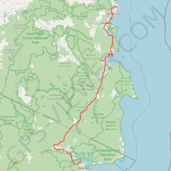
Mallacoota - Tura Beach
#Bike
- Distance: 121.7 Km
- Elevation gain: 2,063 m
- Maximum elevation: 163 m
- Elevation loss: 2,089 m
- Minimum elevation: -1 m
Interactive map
GPS track profile
About this GPS track
Name: Mallacoota - Tura Beach GPS track, route, trail
Coordinates: -37.54534 149.58736 -36.85628 149.93605
Topography: Victoria topographic map
Other GPS tracks
Click on a GPS track to view route, its statistics and profile.
Tura Beach - Bournda National Park - Mimosa Rocks National Park - Dalmeny
Australia > New South Wales > Tura Beach
Distance: 115.2 Km • Elevation gain: 2,019 m • Maximum elevation: 150 m