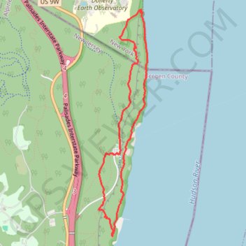
Palisades Interstate Park Loop via White Shore and Long Path
Interactive map
GPS track profile
About this GPS track
Name: Palisades Interstate Park Loop via White Shore and Long Path GPS track, route, trail
Start: Trail F, Alpine, Bergen County, New Jersey, 10964, United States (40.98833 -73.90650)
End: Trail F, Alpine, Bergen County, New Jersey, 10964, United States (40.98833 -73.90650)
Coordinates: 40.97979 -73.90926 41.00357 -73.90253
Other GPS tracks
Click on a GPS track to view route, its statistics and profile.
Palisades Interstate Park Loop
United States > New Jersey > Bergen County > Alpine
Loop hike along the Hudson River via Long Path, Shore Trail, Peanut Leap Cascade, Giant Stairs, Blue and white Trail, State Line Lookout and Border Monument in the Palisades Interstate Park. #Hike #Loop #River #Nature #Forest #Park #Falls #Overlook
Distance: 7.5 Km • Elevation gain: 391 m • Maximum elevation: 164 m
Montréal - New York
Canada > Québec > Agglomération de Montréal > Montréal
Distance: 637.3 Km • Elevation gain: 4,134 m • Maximum elevation: 301 m