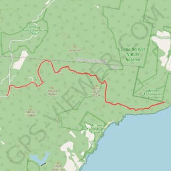
HELLFIRE7 04:43:17 PM
- Distance: 12.3 Km
- Elevation gain: 552 m
- Maximum elevation: 458 m
- Elevation loss: 535 m
- Minimum elevation: 118 m
- Moving time: 2 h 35 m
- Moving speed: 4.7 Km/h
- Maximum speed: 42.3 Km/h
- Total time: 3 h 55 m
- Global speed: 3.1 Km/h
- Date: 03/03/17
Interactive map
GPS track profile
About this GPS track
Name: HELLFIRE7 04:43:17 PM GPS track, route, trail
Start: Helfire Bluff Track, Bream Creek, Sorell, Tasmania, Australia (-42.73441 147.93288)
End: Wielangta Road, Bream Creek, Buckland, Sorell, Tasmania, Australia (-42.73176 147.83824)
Coordinates: -42.73813 147.83824 -42.71620 147.93288
Topography: Tasmania topographic map