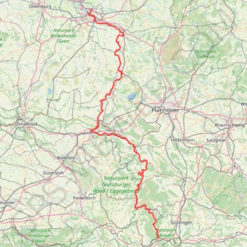
Weser-Radweg on GPSies.com
- Distance: 395.1 Km
- Elevation gain: 2,442 m
- Maximum elevation: 215 m
- Elevation loss: 2,583 m
- Minimum elevation: 2 m
- Moving time: 1 d 15 h
- Moving speed: 9.9 Km/h
- Maximum speed: 10.9 Km/h
- Total time: 1 d 15 h
- Global speed: 9.9 Km/h
- Date: 01/01/10
Interactive map
GPS track profile
About this GPS track
Name: Weser-Radweg on GPSies.com GPS track, route, trail
Coordinates: 51.41256 8.80689 53.11505 9.65863
Other GPS tracks
Click on a GPS track to view route, its statistics and profile.
Rhin par la rive gauche
Suisse > Uri > Korporation Ursern > Andermatt
Vélo. En aller simple entre Andermatt et Hoek van Holland. Suisse centrale. #Vélo #SuisseCentrale #Alpes #Montagne #Nature
Distance: 1,454.5 Km • Elevation gain: 6,868 m • Maximum elevation: 2,047 m
Eurovelo 15 - Entire Route
Pays-Bas > Hollande-Méridionale > Hoek van Holland
Distance: 1,453.6 Km • Elevation gain: 8,277 m • Maximum elevation: 2,047 m
Rhin par la rive gauche
Suisse > Uri > Korporation Ursern > Andermatt
Distance: 1,454.2 Km • Elevation gain: 6,254 m • Maximum elevation: 2,050 m
Stage 14: Frederikshavn to Aars — European Divide Trail
Danemark > Jutland du Nord > Frederikshavn
Distance: 2,225.3 Km • Elevation gain: 28,686 m • Maximum elevation: 1,389 m
Eurovéloroute-15-Route-du-Rhin
Suisse > Uri > Korporation Ursern > Andermatt
Distance: 1,499.0 Km • Elevation gain: 6,966 m • Maximum elevation: 2,046 m
Eurovelo 15 - Entire Route
Pays-Bas > Hollande-Méridionale > Hoek van Holland
Distance: 1,454.1 Km • Elevation gain: 7,752 m • Maximum elevation: 2,050 m
E1_Germany 3
Allemagne > Schleswig-Holstein > Schleswig-Flensburg > Oeversee
Distance: 1,898.0 Km • Elevation gain: 33,186 m • Maximum elevation: 1,446 m
Dag 3 BRemerweg tot Lattrop
Germany > Lower Saxony > Landkreis Celle > Celle
Distance: 277.0 Km • Elevation gain: 643 m • Maximum elevation: 80 m
PT23BS1 Kiel → Lörrach
Germany > Schleswig-Holstein > Kiel
Distance: 1,046.7 Km • Elevation gain: 9,265 m • Maximum elevation: 757 m
Marche-en-Famenne
Belgique > Luxembourg > Marche-en-Famenne > Marche-en-Famenne
<p>From Rue Dupont 46, 6900 Marche-en-Famenne, Belgium<br/> To Avenue de France, 6900 Marche-en-Famenne, Belgium</p> <p>Routing Motor - nicest</p>
Distance: 2,843.5 Km • Elevation gain: 28,856 m • Maximum elevation: 1,078 m
Eurovelo 15 - Entire Route
Pays-Bas > Hollande-Méridionale > Hoek van Holland
Distance: 1,454.1 Km • Elevation gain: 7,752 m • Maximum elevation: 2,050 m
Track vom: 2020-06-27 07:26
Germany > Bavaria > Landkreis Ostallgäu > Halblech
Distance: 688.1 Km • Elevation gain: 4,307 m • Maximum elevation: 911 m
Jour 18 / 27 Juin 2022
Distance: 652.6 Km • Elevation gain: 1,835 m • Maximum elevation: 116 m
Track vom: 2020-06-13 07:00
Germany > North Rhine-Westphalia > Kreis Wesel > Schermbeck
Distance: 679.9 Km • Elevation gain: 5,301 m • Maximum elevation: 921 m
Görlitz - Alpen
Germany > Saxony > Görlitz > Görlitz
Distance: 749.5 Km • Elevation gain: 5,160 m • Maximum elevation: 446 m
Görlitz - Alpen
Germany > Saxony > Görlitz > Görlitz
Distance: 749.5 Km • Elevation gain: 5,160 m • Maximum elevation: 446 m