TET-Belarus-230614
- Distance: 716.7 Km
- Elevation gain: 2,014 m
- Maximum elevation: 202 m
- Elevation loss: 2,027 m
- Minimum elevation: 102 m
Interactive map
GPS track profile
About this GPS track
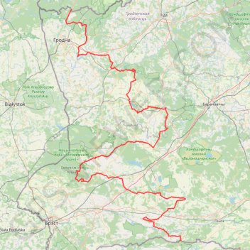
Name: TET-Belarus-230614 GPS track, route, trail
Start: Р144, Махроўскі сельскі Савет, Іванаўскі раён, Voblast de Brest, Bélarus (51.93568 25.54799)
End: Р42, Гожскі сельскі Савет, Гродзенскі раён, Voblast de Hrodna, Bélarus (53.94156 23.97046)
Coordinates: 51.93568 23.87306 53.94156 25.61359
Other GPS tracks
Click on a GPS track to view route, its statistics and profile.
TET_PL-01_20220823
Poland > Podlaskie Voivodeship > Sejny County > Wigrańce
Distance: 1,070.4 Km • Elevation gain: 5,097 m • Maximum elevation: 342 m