GPS tracks, routes, trails, hikes

GPS tracks visualization and sharing, free and without registration.

Import a GPX file

Wilsch Walk

Flat Rock Gully. #Hike #FlatRock #Sydney

  • Distance: 4.8 Km
  • Elevation gain: 143 m
  • Maximum elevation: 53 m
  • Elevation loss: 143 m
  • Minimum elevation: 7 m

Interactive map

GPS track profile

About this GPS track

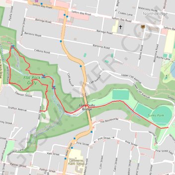
Name: Wilsch Walk GPS track, route, trail.
Start: West Street, Naremburn, Sydney, Willoughby City Council, Lower North Shore, New South Wales, 2065, Australia (-33.81723 151.20879)
End: West Street, Naremburn, Sydney, Willoughby City Council, Lower North Shore, New South Wales, 2065, Australia (-33.81723 151.20879)
Coordinates: -33.81832 151.20627 -33.81319 151.21849

Other GPS tracks

Artarmon Reserve - Flat Rock Gully

Australia > New South Wales > Sydney

#Hike #Loop #Artarmon #Sydney

Distance: 6.3 Km - Elevation gain: 123 m - Maximum elevation: 88 m - Total time: 1 h 37 m - Date: 21/01/20 - Coordinates: -33.81590 151.18447 -33.80797 151.20915

Start: Artamon Post Office, Hampden Road, Gore Hill, Artarmon, Sydney, Willoughby City Council, Lower North Shore, New South Wales, 2064, Australia (-33.80928 151.18577)

End: 38, Hampden Road, Gore Hill, Artarmon, Sydney, Willoughby City Council, Lower North Shore, New South Wales, 2064, Australia (-33.80974 151.18632)