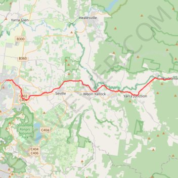
Lilydale - Warburton Rail Trail
#MTB
- Distance: 38.1 Km
- Elevation gain: 452 m
- Maximum elevation: 231 m
- Elevation loss: 388 m
- Minimum elevation: 85 m
Interactive map
GPS track profile
About this GPS track
Name: Lilydale - Warburton Rail Trail GPS track, route, trail
Coordinates: -37.78909 145.34745 -37.75341 145.69039
Topography: Melbourne topographic map
Other GPS tracks
Click on a GPS track to view route, its statistics and profile.
Tallarook - Eildon - Hurstbridge
Australia > Victoria > Tallarook
#Bike
Distance: 278.8 Km • Elevation gain: 4,897 m • Maximum elevation: 868 m