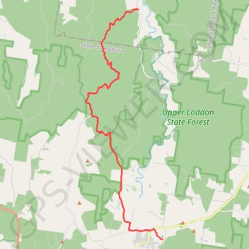
Glen Luce - Glenlyon
#MTB
- Distance: 20.7 Km
- Elevation gain: 495 m
- Maximum elevation: 564 m
- Elevation loss: 298 m
- Minimum elevation: 326 m
Interactive map
GPS track profile
About this GPS track
Name: Glen Luce - Glenlyon GPS track, route, trail
End: Pony Club Road, Glenlyon, Shire of Hepburn, Victoria, Australia (-37.29752 144.25335)
Coordinates: -37.29752 144.20519 -37.18260 144.25335
Topography: Victoria topographic map
Other GPS tracks
Click on a GPS track to view route, its statistics and profile.