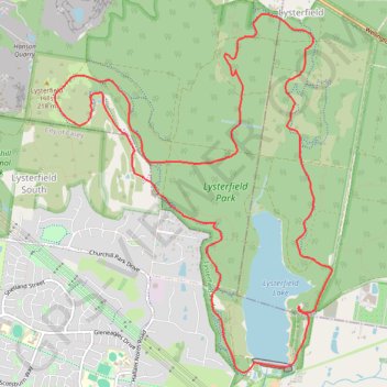
Lysterfield Park MTB Loop
#MTB #Loop #Lysterfield
- Distance: 16.6 Km
- Elevation gain: 380 m
- Maximum elevation: 208 m
- Elevation loss: 380 m
- Minimum elevation: 59 m
Interactive map
GPS track profile
About this GPS track
Name: Lysterfield Park MTB Loop GPS track, route, trail
Coordinates: -37.97198 145.26968 -37.93516 145.30582
Topography: Melbourne topographic map
Other GPS tracks
Click on a GPS track to view route, its statistics and profile.
Lysterfield Lake Loop
Australia > Victoria > Melbourne
Lysterfield Park. #Hike #Loop #Lysterfield
Distance: 5.7 Km • Elevation gain: 83 m • Maximum elevation: 101 m
Lysterfield Lake Loop
Australia > Victoria > Melbourne
Lysterfield Park. #Hike #Loop #Lysterfield
Distance: 6.2 Km • Elevation gain: 92 m • Maximum elevation: 105 m