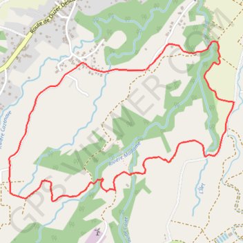
Boucle Davidon
Randonnée / course à pied / trail. En boucle. #Randonnée #Course #Trail #Boucle #Guadeloupe #Mer #Île
- Distance: 6.6 Km
- Elevation gain: 181 m
- Maximum elevation: 145 m
- Elevation loss: 182 m
- Minimum elevation: 17 m
- Moving time: 1 h 34 m
- Moving speed: 4.2 Km/h
- Maximum speed: 6.4 Km/h
- Total time: 1 h 46 m
- Global speed: 3.7 Km/h
- Date: 31/12/08
Interactive map
GPS track profile
About this GPS track
Name: Boucle Davidon GPS track, route, trail
Start: Duzer, Sainte-Rose, Basse-Terre, Guadeloupe, 97115, France (16.33767 -61.73103)
End: Duzer, Sainte-Rose, Basse-Terre, Guadeloupe, 97115, France (16.33765 -61.73093)
Coordinates: 16.32777 -61.74170 16.33980 -61.72407
Other GPS tracks
Click on a GPS track to view route, its statistics and profile.
Boucle Davidon
France > Guadeloupe > Sainte-Rose > Duzer
Distance: 6.5 Km • Elevation gain: 177 m • Maximum elevation: 145 m