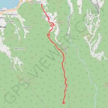
07-DEC-15 12:51:23 PM
- Distance: 13.9 Km
- Elevation gain: 986 m
- Maximum elevation: 899 m
- Elevation loss: 986 m
- Minimum elevation: 142 m
- Moving time: 3 h 31 m
- Moving speed: 3.9 Km/h
- Maximum speed: 8.2 Km/h
- Total time: 5 h 2 m
- Global speed: 2.7 Km/h
- Date: 08/12/15
Interactive map
GPS track profile
About this GPS track
Name: 07-DEC-15 12:51:23 PM GPS track, route, trail
Coordinates: -17.56295 -149.50084 -17.52078 -149.48961
Other GPS tracks
Click on a GPS track to view route, its statistics and profile.
02-JAN-16 02:37:35 PM
France > Polynésie française > Îles du Vent > Arue
Distance: 13.8 Km • Elevation gain: 871 m • Maximum elevation: 945 m