Tenaya Creek and Mirror Lake
Interactive map
GPS track profile
About this GPS track
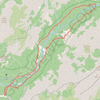
Name: Tenaya Creek and Mirror Lake GPS track, route, trail
End: Curry Village, Mariposa County, California, United States (37.73945 -119.55980)
Coordinates: 37.73936 -119.55987 37.75981 -119.53429
Other GPS tracks
Click on a GPS track to view route, its statistics and profile.
Yosemite North Dome Loop
United States > California > Mariposa County > Curry Village
Loop hike to North Dome via Lower Mirror Lake, Tenaya Creek, Valley Loop Trail, Snow Creek Trail, North Dome Trail, Upper Yosemite Fall Trail, Oh My Gosh Point and Columbia Rock in the Yosemite National Park. #Hike #Loop #Mountain #Nature #Lake #Forest #Fall #Park #Yosemite
Distance: 32.0 Km • Elevation gain: 2,275 m • Maximum elevation: 2,484 m
JMT1-16847633
États-Unis d'Amérique > Californie > Inyo County
Distance: 401.4 Km • Elevation gain: 15,190 m • Maximum elevation: 4,385 m
Walker - Auberry
États-Unis d'Amérique > Californie > Mono County > Walker
Vélo. En aller simple entre Walker et Auberry. #Vélo
Distance: 354.0 Km • Elevation gain: 6,633 m • Maximum elevation: 3,039 m