Geiranger
Randonnée pédestre. #Randonnée
- Distance: 7.2 Km
- Elevation gain: 211 m
- Maximum elevation: 125 m
- Elevation loss: 234 m
- Minimum elevation: -1 m
- Moving time: 2 h 6 m
- Moving speed: 3.4 Km/h
- Maximum speed: 15.6 Km/h
- Total time: 3 h 19 s
- Global speed: 2.4 Km/h
- Date: 22/07/14
Interactive map
GPS track profile
About this GPS track
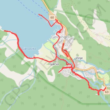
Name: Geiranger GPS track, route, trail
Start: 34, Geirangervegen, Maråk, Geiranger, Stranda, Møre og Romsdal, 6216, Norvège (62.09957 7.20664)
End: 60, Maråk, Geiranger, Stranda, Møre og Romsdal, 6216, Norvège (62.10361 7.19985)
Coordinates: 62.09278 7.18986 62.10361 7.21881
Other GPS tracks
Click on a GPS track to view route, its statistics and profile.
Geiranger to Keipane
Norvège > Møre og Romsdal > Geiranger
Randonnée en aller-retour depuis Geiranger. #Randonnée
Distance: 19.6 Km • Elevation gain: 1,708 m • Maximum elevation: 1,302 m
Homlong - Geiranger
Norvège > Møre og Romsdal > Geiranger > Homlung
Randonnée pédestre. #Randonnée
Distance: 16.3 Km • Elevation gain: 1,290 m • Maximum elevation: 547 m