Trail Planner Map
- Distance: 6.7 Km
- Elevation gain: 333 m
- Maximum elevation: 1,170 m
- Elevation loss: 333 m
- Minimum elevation: 881 m
Interactive map
GPS track profile
About this GPS track
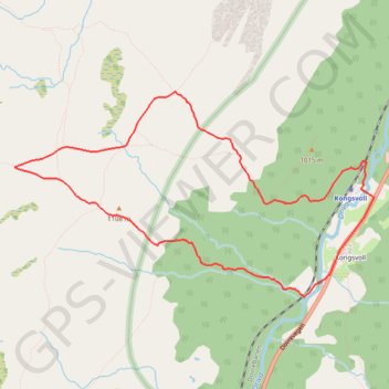
Name: Trail Planner Map GPS track, route, trail
Start: Kongsvoll, Oppdal, Trøndelag, Norvège (62.30700 9.60716)
End: Kongsvoll, Oppdal, Trøndelag, Norvège (62.30700 9.60720)
Coordinates: 62.30063 9.56288 62.31277 9.60884
Other GPS tracks
Click on a GPS track to view route, its statistics and profile.
Trail Planner Map
Norvège > Trøndelag > Kongsvoll
Distance: 6.0 Km • Elevation gain: 334 m • Maximum elevation: 1,170 m