Auburn State Recreation Area
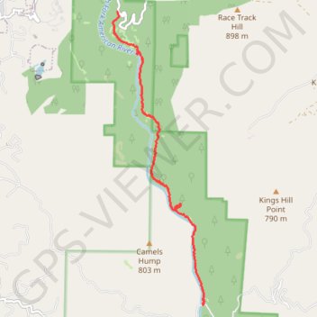
Hike from Iowa Hill Road to Yankee Jims Bridge along the North Fork American River via Windy Point Trail and Indian Creek Trail in the Auburn State Recreation Area. #Hike #Nature #Mountain #River #Forest
- Distance: 8.6 Km
- Elevation gain: 385 m
- Maximum elevation: 510 m
- Elevation loss: 578 m
- Minimum elevation: 282 m
- Moving time: 3 h 35 m
- Moving speed: 2.4 Km/h
- Maximum speed: 6.1 Km/h
- Total time: 5 h 49 m
- Global speed: 1.5 Km/h
- Date: 06/11/11
Interactive map
GPS track profile
About this GPS track
Name: Auburn State Recreation Area GPS track, route, trail
Start: Windy Point Trail, Placer County, California, 95713, United States (39.09081 -120.92120)
End: Yankee Jims Road, Placer County, California, United States (39.04027 -120.90217)
Coordinates: 39.04025 -120.92224 39.09081 -120.90193
Other GPS tracks
Click on a GPS track to view route, its statistics and profile.
Chester - Walker
États-Unis d'Amérique > Californie > Plumas County > Chester
Vélo. En aller simple entre Chester et Walker. #Vélo
Distance: 383.8 Km • Elevation gain: 6,088 m • Maximum elevation: 2,541 m