Descente Tunupa
Randonnée pédestre. En aller simple. #Randonnée
- Distance: 6.9 Km
- Elevation gain: 8 m
- Maximum elevation: 4,638 m
- Elevation loss: 952 m
- Minimum elevation: 3,685 m
- Moving time: 2 h 2 m
- Moving speed: 3.4 Km/h
- Maximum speed: 4.4 Km/h
- Total time: 2 h 13 m
- Global speed: 3.1 Km/h
- Date: 22/09/12
Interactive map
GPS track profile
About this GPS track
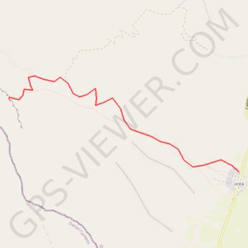
Name: Descente Tunupa GPS track, route, trail
Coordinates: -19.85530 -67.61960 -19.83711 -67.57328
Other GPS tracks
Click on a GPS track to view route, its statistics and profile.
Ascension Tunupa
Bolivie > Oruro > Ladislao Cabrera > Salinas de Garcí Mendoza > Jirira > Jirira
Randonnée depuis Jirira. #Randonnée
Distance: 7.6 Km • Elevation gain: 955 m • Maximum elevation: 4,638 m