Atlanta Critical Mass
- Distance: 23.3 Km
- Elevation gain: 334 m
- Maximum elevation: 342 m
- Elevation loss: 337 m
- Minimum elevation: 263 m
- Moving time: 1 h 47 m
- Moving speed: 13.0 Km/h
- Maximum speed: 37.0 Km/h
- Total time: 2 h 4 m
- Global speed: 11.2 Km/h
- Date: 30/09/23
Interactive map
GPS track profile
About this GPS track
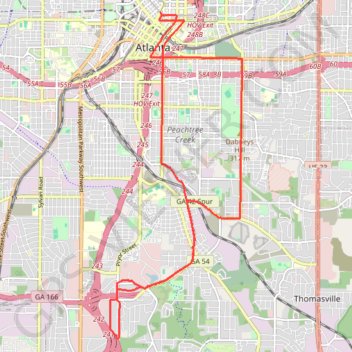
Name: Atlanta Critical Mass GPS track, route, trail
Coordinates: 33.68905 -84.40075 33.75602 -84.36812
Other GPS tracks
Click on a GPS track to view route, its statistics and profile.
Atlanta Critical Mass bike ride
United States > Georgia > Fulton County > Atlanta
Distance: 14.2 Km • Elevation gain: 207 m • Maximum elevation: 361 m
The Atlanta Donut Ride
United States > Georgia > Fulton County > Atlanta
Distance: 16.4 Km • Elevation gain: 237 m • Maximum elevation: 352 m