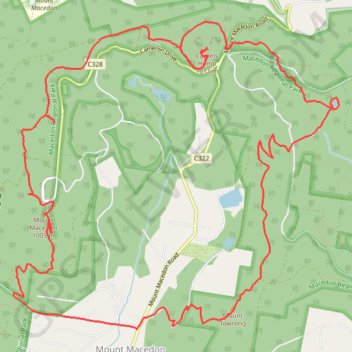
Macedon ranges walking track
- Distance: 19.8 Km
- Elevation gain: 731 m
- Maximum elevation: 990 m
- Elevation loss: 731 m
- Minimum elevation: 584 m
- Moving time: 2 h 40 m
- Moving speed: 7.4 Km/h
- Maximum speed: 20.7 Km/h
- Total time: 3 h 24 m
- Global speed: 5.8 Km/h
- Date: 14/05/24
Interactive map
GPS track profile
About this GPS track
Name: Macedon ranges walking track GPS track, route, trail
Coordinates: -37.39992 144.57182 -37.36736 144.61509
Topography: Victoria topographic map
Other GPS tracks
Click on a GPS track to view route, its statistics and profile.