Peter Skene Ogden Trail to the Paulina Lake
Hike to the Paulina Lake by the Peter Skene Ogden Trail along the Paulina Creek via McKay Crossing Falls and Paulina Falls in the Newberry National Volcanic Monument and the Deschutes National Forest. #Hike #Mountain #River #Forest #Falls #Nature #Volcano #Lake
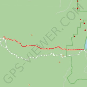
- Distance: 13.7 Km
- Elevation gain: 632 m
- Maximum elevation: 1,938 m
- Elevation loss: 9 m
- Minimum elevation: 1,313 m
Interactive map
GPS track profile
About this GPS track
Name: Peter Skene Ogden Trail to the Paulina Lake GPS track, route, trail
Start: Peter Skene Ogden Trail, Deschutes County, Oregon, United States (43.72865 -121.41887)
End: Deschutes County, Oregon, United States (43.71301 -121.27779)
Coordinates: 43.71206 -121.41887 43.72880 -121.27779
Other GPS tracks
Click on a GPS track to view route, its statistics and profile.
Bend to Alvord Section 1 - Bend to Christmas Valley Sand Dunes
United States > Oregon > Deschutes County > Bend
Distance: 158.7 Km • Elevation gain: 887 m • Maximum elevation: 1,559 m
Northern part of the Pacific Crest Trail (PCT)
United States > Oregon > Klamath County
Hike on the Pacific Crest National Scenic Trail from Crater Lake to Canada Border through Oregon and Washington along the Sierra Nevada and Cascade mountain ranges. #Hike #Mountain #SierraNevada #Cascade #Nature #Forest #Park #PCT
Distance: 1,198.3 Km • Elevation gain: 44,308 m • Maximum elevation: 2,307 m
Sisters - Ashland
États-Unis d'Amérique > Oregon > Deschutes County
Vélo. En aller simple entre Bend et Ashland. #Vélo
Distance: 473.8 Km • Elevation gain: 5,675 m • Maximum elevation: 2,335 m