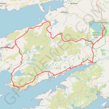
The-kerry-way-entire-trail-walking-route-map-and-guide-kerry-ireland
- Distance: 201.2 Km
- Elevation gain: 5,003 m
- Maximum elevation: 380 m
- Elevation loss: 5,004 m
- Minimum elevation: 3 m
Interactive map
GPS track profile
About this GPS track
Name: The-kerry-way-entire-trail-walking-route-map-and-guide-kerry-ireland GPS track, route, trail
Coordinates: 51.76614 -10.22772 52.06399 -9.49141
Other GPS tracks
Click on a GPS track to view route, its statistics and profile.
Purple Mountain
Distance: 15.4 Km • Elevation gain: 861 m • Maximum elevation: 818 m
Waterville - Derrynane Beach - Caherdaniel
#Hike
Distance: 16.2 Km • Elevation gain: 439 m • Maximum elevation: 243 m
Trace IRELAND
Distance: 1,506.7 Km • Elevation gain: 13,359 m • Maximum elevation: 524 m
RT5-1 Rosslare - Kinsale
Distance: 2,860.3 Km • Elevation gain: 27,381 m • Maximum elevation: 420 m
RT5-1 Rosslare - Kinsale
Distance: 3,867.1 Km • Elevation gain: 36,115 m • Maximum elevation: 524 m
RT5-1 Rosslare - Kinsale
Distance: 1,353.5 Km • Elevation gain: 15,245 m • Maximum elevation: 420 m