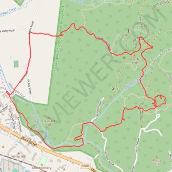
Quartz Hill, Garfield WW and Goldfields Track walk
- Distance: 7.9 Km
- Elevation gain: 147 m
- Maximum elevation: 393 m
- Elevation loss: 148 m
- Minimum elevation: 297 m
- Moving time: 1 h 43 m
- Moving speed: 4.6 Km/h
- Maximum speed: 33.8 Km/h
- Total time: 1 h 56 m
- Global speed: 4.1 Km/h
Interactive map
GPS track profile
About this GPS track
Name: Quartz Hill, Garfield WW and Goldfields Track walk GPS track, route, trail
Coordinates: -37.07641 144.23880 -37.06271 144.26055
Topography: Victoria topographic map, elevation, terrain
Other GPS tracks
Click on a GPS track to view its route, statistics and profile.
Specimen Gully, Pineys, Golden Point Res, Garfield Water Wheel, Chewton, Castlemaine, Botanic gardens walk
Distance: 18.3 Km • Elevation gain: 269 m • Maximum elevation: 468 m