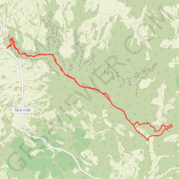
Barranco Mortero
Randonnée en aller-retour depuis Alacón. #Randonnée
- Distance: 10.3 Km
- Elevation gain: 319 m
- Maximum elevation: 830 m
- Elevation loss: 319 m
- Minimum elevation: 673 m
- Moving time: 2 h 57 m
- Moving speed: 3.5 Km/h
- Maximum speed: 7.1 Km/h
- Total time: 4 h 36 m
- Global speed: 2.2 Km/h
- Date: 06/10/13
Interactive map
GPS track profile
About this GPS track
Name: Barranco Mortero GPS track, route, trail
Start: TE-V-1101, Alacón, Andorra-Sierra de Arcos, Teruel, Aragon, Espagne (41.06491 -0.71534)
End: TE-V-1101, Alacón, Andorra-Sierra de Arcos, Teruel, Aragon, Espagne (41.06489 -0.71532)
Coordinates: 41.04757 -0.71534 41.06681 -0.67423
Other GPS tracks
Click on a GPS track to view route, its statistics and profile.
Southern section — European Divide Trail
France > Auvergne-Rhône-Alpes > Drôme > Valence
Distance: 2,423.8 Km • Elevation gain: 42,375 m • Maximum elevation: 2,005 m
1 LUCENA - MONTPELLIER
Distance: 2,964.4 Km • Elevation gain: 29,500 m • Maximum elevation: 1,048 m
1 LUCENA - MONTPELLIER
Espagne > Andalousie > Lucena
Distance: 2,964.4 Km • Elevation gain: 29,500 m • Maximum elevation: 1,048 m
Stage 26: Valence to Saint-Jean-de-Fos — European Divide Trail
France > Auvergne-Rhône-Alpes > Drôme > Valence
Distance: 2,423.8 Km • Elevation gain: 42,375 m • Maximum elevation: 2,005 m
Stage 26: Valence to Saint-Jean-de-Fos — European Divide Trail
France > Auvergne-Rhône-Alpes > Drôme > Valence
Distance: 1,629.8 Km • Elevation gain: 30,841 m • Maximum elevation: 2,005 m