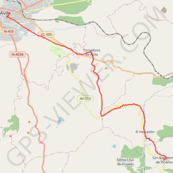
SE22-SanBartolomeDP-Avila
Total: 25.1km
- Distance: 25.1 Km
- Elevation gain: 637 m
- Maximum elevation: 1,377 m
- Elevation loss: 544 m
- Minimum elevation: 914 m
Interactive map
GPS track profile
About this GPS track
Name: SE22-SanBartolomeDP-Avila GPS track, route, trail
Coordinates: 40.54322 -4.69900 40.65624 -4.53733
Other GPS tracks
Click on a GPS track to view route, its statistics and profile.
EuroVelo 1 (Spain)
Espagne > Andalousie > Côte occidentale > Ayamonte
Distance: 1,355.6 Km • Elevation gain: 14,587 m • Maximum elevation: 1,320 m
Southern section — European Divide Trail
France > Auvergne-Rhône-Alpes > Drôme > Valence
Distance: 2,423.8 Km • Elevation gain: 42,375 m • Maximum elevation: 2,005 m
Eurovelo 01 Spain + Portugal
France > Nouvelle-Aquitaine > Pyrénées-Atlantiques > Hendaye
Distance: 3,107.2 Km • Elevation gain: 30,592 m • Maximum elevation: 1,503 m
Stage 26: Valence to Saint-Jean-de-Fos — European Divide Trail
France > Auvergne-Rhône-Alpes > Drôme > Valence
Distance: 2,423.8 Km • Elevation gain: 42,375 m • Maximum elevation: 2,005 m
EuroVelo 1 (Spain)
Espagne > Andalousie > Côte occidentale > Ayamonte > Pozo del Camino > Fotea
Distance: 1,349.7 Km • Elevation gain: 13,641 m • Maximum elevation: 1,320 m
SE21-Cebreros-SanBartolomeDP
Espagne > Castille-et-León > Cebreros
Total: 15.6km
Distance: 15.6 Km • Elevation gain: 607 m • Maximum elevation: 1,246 m
SE23-Avila-Gotarrendura
Espagne > Castille-et-León > Ávila
Total: 23.4km
Distance: 23.4 Km • Elevation gain: 263 m • Maximum elevation: 1,177 m