Move
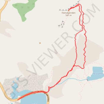
- Distance: 3.1 Km
- Elevation gain: 531 m
- Maximum elevation: 536 m
- Elevation loss: 531 m
- Minimum elevation: 5 m
- Moving time: 52 m 16 s
- Moving speed: 3.6 Km/h
- Maximum speed: 14.0 Km/h
- Total time: 57 m 57 s
- Global speed: 3.2 Km/h
- Date: 03/09/17
Interactive map
GPS track profile
About this GPS track
Name: Move GPS track, route, trail
Start: Henningsværveien, Festvåg, Vågan, Nordland, 8312, Norvège (68.17115 14.21479)
End: Henningsværveien, Festvåg, Vågan, Nordland, 8312, Norvège (68.17110 14.21462)
Coordinates: 68.17110 14.21462 68.17855 14.22901
Other GPS tracks
Click on a GPS track to view route, its statistics and profile.
Stage 1: Arctic Ocean to Väylä — European Divide Trail
Distance: 2,785.0 Km • Elevation gain: 23,823 m • Maximum elevation: 722 m