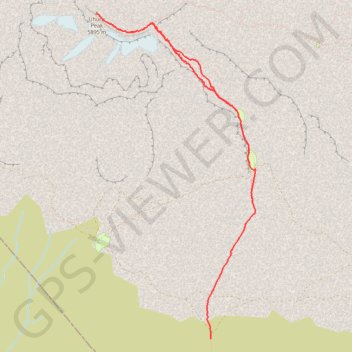
Machame - J6
Randonnée pédestre. #Randonnée
- Distance: 13.5 Km
- Elevation gain: 1,223 m
- Maximum elevation: 5,871 m
- Elevation loss: 1,958 m
- Minimum elevation: 3,913 m
Interactive map
GPS track profile
About this GPS track
Name: Machame - J6 GPS track, route, trail
Start: Barafu Camp, Scree Slope, Rombo, Kilimandjaro, Northern Zone, Tanzanie (-3.10028 37.37830)
End: Millenium Camp, Scree Slope, Rombo, Kilimandjaro, Northern Zone, Tanzanie (-3.12813 37.37219)
Coordinates: -3.12813 37.35404 -3.07649 37.37926
Other GPS tracks
Click on a GPS track to view route, its statistics and profile.
Kilimanjaro - Voie Lemosho 9 jours
Randonnée pédestre. #Randonnée
Distance: 50.4 Km • Elevation gain: 3,556 m • Maximum elevation: 5,877 m
Machame - J4
Randonnée pédestre. En aller simple. #Randonnée
Distance: 4.8 Km • Elevation gain: 416 m • Maximum elevation: 4,216 m
Machame - J5
Randonnée pédestre. En aller simple. #Randonnée
Distance: 3.6 Km • Elevation gain: 633 m • Maximum elevation: 4,657 m
Machame - J7
Randonnée pédestre. En aller simple. #Randonnée
Distance: 13.1 Km • Elevation gain: 0 m • Maximum elevation: 3,914 m
Montée Finale Kilimanjaro
Randonnée pédestre. En aller-retour. #Randonnée
Distance: 10.4 Km • Elevation gain: 1,173 m • Maximum elevation: 5,872 m