Boucher Fire Lookout
Interactive map
GPS track profile
About this GPS track
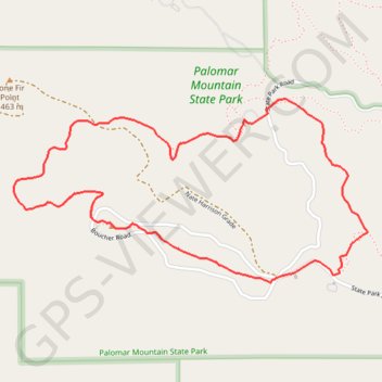
Name: Boucher Fire Lookout GPS track, route, trail
Start: State Park Road, San Diego County, California, 92060, United States (33.33245 -116.90681)
End: Scott's Cabin Trail, San Diego County, California, 92060, United States (33.33251 -116.90671)
Coordinates: 33.33213 -116.92420 33.34052 -116.90491
Other GPS tracks
Click on a GPS track to view route, its statistics and profile.