CTS-N.Irelandv1.1-Belfast-Titanic>Enniscrone-via antrim coast-209miles
- Distance: 335.8 Km
- Elevation gain: 3,985 m
- Maximum elevation: 271 m
- Elevation loss: 3,981 m
- Minimum elevation: 0 m
Interactive map
GPS track profile
About this GPS track
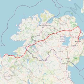
Name: CTS-N.Irelandv1.1-Belfast-Titanic>Enniscrone-via antrim coast-209miles GPS track, route, trail
Coordinates: 54.19749 -9.09619 54.97053 -5.80606
Other GPS tracks
Click on a GPS track to view route, its statistics and profile.
Cnoc Ramhar
#Hike #Loop #CnocRamhar #Atlantic
Distance: 11.6 Km • Elevation gain: 645 m • Maximum elevation: 568 m
Belfast to Dungannon
United Kingdom > Northern Ireland > County Antrim > Belfast
Bicycle ride from Belfast Big Fish to Dungannon.
Distance: 83.3 Km • Elevation gain: 549 m • Maximum elevation: 75 m
RT5-1 Rosslare - Kinsale
Distance: 2,860.3 Km • Elevation gain: 27,381 m • Maximum elevation: 420 m
TT22 J4 J2/06 : Dublin à Belfast
Irlande > County Dublin > Dublin
Distance: 250.3 Km • Elevation gain: 2,609 m • Maximum elevation: 390 m
RT5-1 Rosslare - Kinsale
Distance: 3,867.1 Km • Elevation gain: 36,115 m • Maximum elevation: 524 m
Foyle Valley Cycle Route
United Kingdom > Northern Ireland > County Londonderry > Derry/Londonderry
Distance: 8.4 Km • Elevation gain: 63 m • Maximum elevation: 38 m
Lagan & Lough
United Kingdom > Northern Ireland > County Antrim > Tullynacross
Distance: 29.4 Km • Elevation gain: 153 m • Maximum elevation: 35 m
TT22 J5 V3/06 : Belfast à Belfast
Royaume-Uni > Irlande du Nord > County Antrim > Belfast
Distance: 252.4 Km • Elevation gain: 2,552 m • Maximum elevation: 264 m
Newry Canal Towpath
United Kingdom > Northern Ireland > County Armagh > Portadown
Distance: 32.3 Km • Elevation gain: 95 m • Maximum elevation: 29 m