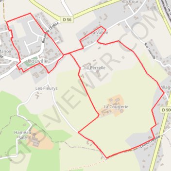
1 - Marche_5
Marche 5 km
- Distance: 4.9 Km
- Elevation gain: 66 m
- Maximum elevation: 100 m
- Elevation loss: 66 m
- Minimum elevation: 75 m
Interactive map
GPS track profile
About this GPS track
Name: 1 - Marche_5 GPS track, route, trail
Coordinates: 49.54616 -1.68904 49.55649 -1.67167
Other GPS tracks
Click on a GPS track to view route, its statistics and profile.
GR 223 Tour du Cotentin (2021)
France > Normandie > Eure > Berville-sur-Mer
Randonnée en Normandie sur le GR 223 autour du Cotentin à travers l'Eure, le Calvados et la Manche de Berville-sur-Mer au Mont-Saint-Michel.
Distance: 650.7 Km • Elevation gain: 6,685 m • Maximum elevation: 149 m
Tour d'Europe
France > Bretagne > Finistère > Concarneau > Landan Creis
Distance: 7,132.9 Km • Elevation gain: 44,603 m • Maximum elevation: 2,433 m
Sentier Cotentin - Cherbourg vers Mont-Saint-Michel
France > Normandie > Manche > La Hague > Urville-Nacqueville > La Rivière
Distance: 231.7 Km • Elevation gain: 2,584 m • Maximum elevation: 128 m
GR223 - Cherbourg à Coutances
France > Normandie > Manche > Cherbourg-en-Cotentin
Randonnée entre Cherbourg-Octeville et Coutances. #Randonnée
Distance: 201.4 Km • Elevation gain: 2,106 m • Maximum elevation: 138 m
RAF 2022 / 2600 n1 News
France > Hauts-de-France > Pas-de-Calais > Le Touquet-Paris-Plage
Distance: 2,594.8 Km • Elevation gain: 39,725 m • Maximum elevation: 2,766 m
Randonnée de Cherbourg à Portbail par le GR 223
France > Normandie > Manche > Cherbourg-en-Cotentin
Randonnée sur sentier du littoral à travers la Manche de Cherbourg à Portbail via Equeurdreville, Urville-Nacqueville, Hameau aux Fèvres (Greville-Hague), Digulleville, Herqueville, Biville, Les Pieux, Surtainville, Baubigny, Barneville-Carteret et Barneville-Carteret. #Randonnée #GR223 #Normandie #Manche #Mer #Nature
Distance: 110.6 Km • Elevation gain: 2,100 m • Maximum elevation: 131 m
1 - Vélo 2024 - 100 km
France > Normandie > Manche > Martinvast > Les Rosées
Cyclisme sur routes départementales et communales
Distance: 100.0 Km • Elevation gain: 1,066 m • Maximum elevation: 178 m
GR22 - De Cherbourg à Flamanville
France > Normandie > Manche > Cherbourg-en-Cotentin
Randonnée entre Cherbourg-Octeville et Flamanville. #Randonnée
Distance: 70.2 Km • Elevation gain: 1,477 m • Maximum elevation: 131 m
Itinéraire de Nemours à Nemours
France > Centre-Val de Loire > Loiret > Bromeilles > Bainvilliers
Distance: 1,576.4 Km • Elevation gain: 8,536 m • Maximum elevation: 238 m
1 - etape-3-tdn-2024-parcours (1)
France > Normandie > Manche > Coutances
Etape 3 16 mars 2024
Distance: 137.1 Km • Elevation gain: 1,831 m • Maximum elevation: 157 m
GR223 De Tourlaville à Portbail (Manche)
France > Normandie > Manche > Cherbourg-en-Cotentin
Randonnée entre Cherbourg-Octeville et Portbail. #Randonnée
Distance: 110.2 Km • Elevation gain: 2,026 m • Maximum elevation: 131 m
Les chemins de Saint-Michel - Cherbourg - Lessay
France > Normandie > Manche > Cherbourg-en-Cotentin
Randonnée entre Cherbourg-Octeville et Lessay. #Randonnée
Distance: 90.9 Km • Elevation gain: 788 m • Maximum elevation: 164 m
Tous les coins du Cotentin-12150732
France > Normandie > Manche > Saint-Floxel
Distance: 317.9 Km • Elevation gain: 3,204 m • Maximum elevation: 168 m
RdA 2022 E3
France > Normandie > Manche > Le Havre de Quinéville > Les Roques
Distance: 103.6 Km • Elevation gain: 1,251 m • Maximum elevation: 166 m
La tollevataise 2019
France > Normandie > Manche > Tollevast > La Tourelle
Distance: 51.4 Km • Elevation gain: 821 m • Maximum elevation: 150 m
Couville hardinvast glacerie
France > Normandie > Manche > Cherbourg-en-Cotentin
Distance: 48.6 Km • Elevation gain: 547 m • Maximum elevation: 177 m
Evening Mar 27th
France > Normandie > Manche > Cherbourg-en-Cotentin
Distance: 151.7 Km • Elevation gain: 1,304 m • Maximum elevation: 153 m