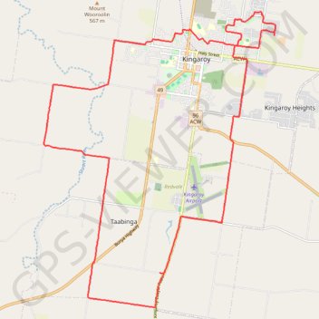
Kingaroy Taabinga Boonenne trace
Loop bike around Kingaroy. #Bike #Loop #Countryside #Nature #Forest
- Distance: 36.8 Km
- Elevation gain: 368 m
- Maximum elevation: 542 m
- Elevation loss: 368 m
- Minimum elevation: 409 m
- Moving time: 2 h 17 m
- Moving speed: 16.0 Km/h
- Maximum speed: 48.7 Km/h
- Total time: 2 h 28 m
- Global speed: 14.9 Km/h
- Date: 14/03/24
Interactive map
GPS track profile
About this GPS track
Name: Kingaroy Taabinga Boonenne trace GPS track, route, trail
Start: Wattle Street, Kingaroy, South Burnett Regional, Queensland, Australia (-26.52753 151.86064)
End: Wattle Street, Kingaroy, South Burnett Regional, Queensland, Australia (-26.52759 151.86066)
Coordinates: -26.61410 151.78946 -26.52753 151.86549
Topography: Queensland topographic map
Other GPS tracks
Click on a GPS track to view route, its statistics and profile.
Murgon - Kingaroy
Australia > Queensland > Murgon
#Bike
Distance: 48.4 Km • Elevation gain: 335 m • Maximum elevation: 489 m
Taabinga and Wattle Grove
Australia > Queensland > Kingaroy
Kingaroy, Taabinga, Inverlaw, Wattle Grove
Distance: 54.3 Km • Elevation gain: 474 m • Maximum elevation: 542 m
Booie and Crawford, Qld Aus
Australia > Queensland > Kingaroy
Booie, Crawford, Kingaroy, Queensland
Distance: 38.1 Km • Elevation gain: 496 m • Maximum elevation: 569 m
Booie loop
Australia > Queensland > Kingaroy
Booie, Kingaroy, Sandy Ridges, Queensland
Distance: 47.7 Km • Elevation gain: 511 m • Maximum elevation: 569 m
Memerambi - Corndale loop
Australia > Queensland > Kingaroy
Memerambi, Corndale, Booie, Kingaroy, Queensland
Distance: 45.5 Km • Elevation gain: 557 m • Maximum elevation: 569 m
Booie and Schellbachs Road near Kingaroy
Australia > Queensland > Kingaroy
Distance: 23.2 Km • Elevation gain: 356 m • Maximum elevation: 591 m
Kingaroy to Goodger Queensland
Australia > Queensland > Kingaroy
Goodger, Taabinga, Kingaroy, Boonenne, Queensland
Distance: 38.4 Km • Elevation gain: 300 m • Maximum elevation: 542 m
Memerambi
Australia > Queensland > Kingaroy
West side Memerambi and Crawford
Distance: 37.9 Km • Elevation gain: 294 m • Maximum elevation: 558 m