Point Reyes Loop
- Distance: 100.3 Km
- Elevation gain: 1,900 m
- Maximum elevation: 236 m
- Elevation loss: 1,894 m
- Minimum elevation: 0 m
- Moving time: 6 h 32 m
- Moving speed: 15.3 Km/h
- Maximum speed: 39.7 Km/h
- Total time: 6 h 32 m
- Global speed: 15.3 Km/h
- Date: 25/09/20
Interactive map
GPS track profile
About this GPS track
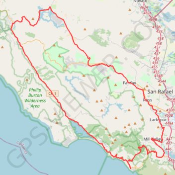
Name: Point Reyes Loop GPS track, route, trail
Coordinates: 37.86288 -122.80631 38.09731 -122.52322
Other GPS tracks
Click on a GPS track to view route, its statistics and profile.
Muir Woods Canopy Trail Loop
United States > California > Marin County
Loop hike through Muir Woods National Monument via Canopy Trail and Fern Creek Trail along the Fern Creek and the Redwook Creek via the Redwood Tree Slice, the Pinchot Tree and the Cathedral Grove. #Hike #Loop #Forest #Nature #Mountain #River
Distance: 4.7 Km • Elevation gain: 247 m • Maximum elevation: 220 m
Muir Woods Bootjack Trail Loop
United States > California > Marin County
Loop hike via Fern Creek Trail, Bootjack Trail, TCC Trail, Stapleveldt Trail, Ben Johnson Trail and Hillside Trail in the Muir Woods National Monument and Mount Tamalpais State Park. #Hike #Loop #Forest #River #Nature #Mountain #Park
Distance: 9.5 Km • Elevation gain: 506 m • Maximum elevation: 410 m