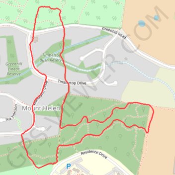
Mount Helen Afternoon Walk
Mapping tracks while walking dogs
- Distance: 2.8 Km
- Elevation gain: 49 m
- Maximum elevation: 542 m
- Elevation loss: 49 m
- Minimum elevation: 508 m
- Moving time: 35 m 26 s
- Moving speed: 4.7 Km/h
- Maximum speed: 6.9 Km/h
- Total time: 36 m 9 s
- Global speed: 4.6 Km/h
Interactive map
GPS track profile
About this GPS track
Name: Mount Helen Afternoon Walk GPS track, route, trail
Coordinates: -37.62299 143.88896 -37.61641 143.89574
Topography: Ballarat topographic map, elevation, terrain
Other GPS tracks
Click on a GPS track to view its route, statistics and profile.
Woowookarung Park with puppies to look at new tracks
Australia > Victoria > Ballarat
Morning Walk
Distance: 1.3 Km • Elevation gain: 18 m • Maximum elevation: 525 m