Munda Biddi Trail
- Distance: 109.7 Km
- Elevation gain: 1,610 m
- Maximum elevation: 331 m
- Elevation loss: 1,462 m
- Minimum elevation: 66 m
Interactive map
GPS track profile
About this GPS track
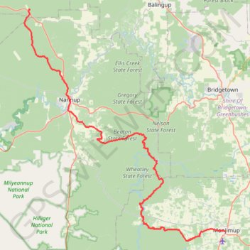
Name: Munda Biddi Trail GPS track, route, trail
Start: Middle Road, Jarrahwood, City Of Busselton, Australie occidentale, Australie (-33.79655 115.66687)
Coordinates: -34.26345 115.65437 -33.79584 116.14459
Other GPS tracks
Click on a GPS track to view route, its statistics and profile.
Perth to Sydney
Australie > Australie occidentale > City of Belmont
Distance: 3,801.3 Km • Elevation gain: 14,558 m • Maximum elevation: 1,159 m