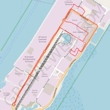
13 Dec 2023 - trip
- Distance: 12.8 Km
- Elevation gain: 53 m
- Maximum elevation: 16 m
- Elevation loss: 53 m
- Minimum elevation: 1 m
- Moving time: 39 m 33 s
- Moving speed: 19.4 Km/h
- Maximum speed: 43.9 Km/h
- Total time: 42 m 45 s
- Global speed: 17.9 Km/h
- Date: 13/12/23
Interactive map
GPS track profile
About this GPS track
Name: 13 Dec 2023 - trip GPS track, route, trail
Coordinates: -27.39086 153.16338 -27.36691 153.18592
Topography: Queensland topographic map