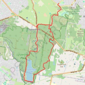
Upwey - Lysterfield Lake
- Distance: 24.5 Km
- Elevation gain: 735 m
- Maximum elevation: 211 m
- Elevation loss: 763 m
- Minimum elevation: 62 m
Interactive map
GPS track profile
About this GPS track
Name: Upwey - Lysterfield Lake GPS track, route, trail
Coordinates: -37.97120 145.29253 -37.91682 145.32520
Topography: Melbourne topographic map
Other GPS tracks
Click on a GPS track to view route, its statistics and profile.
Lysterfield Lake Loop
Australia > Victoria > Melbourne
Lysterfield Park. #Hike #Loop #Lysterfield
Distance: 5.7 Km • Elevation gain: 83 m • Maximum elevation: 101 m
Lysterfield Park MTB Loop
Australia > Victoria > Melbourne
#MTB #Loop #Lysterfield
Distance: 16.6 Km • Elevation gain: 380 m • Maximum elevation: 208 m
Lysterfield Lake Loop
Australia > Victoria > Melbourne
Lysterfield Park. #Hike #Loop #Lysterfield
Distance: 6.2 Km • Elevation gain: 92 m • Maximum elevation: 105 m
Lysterfield, Baluk William, Mount Morton, Birdsland
Australia > Victoria > Melbourne
Distance: 12.9 Km • Elevation gain: 365 m • Maximum elevation: 267 m