New York City Marathon
Interactive map
GPS track profile
About this GPS track
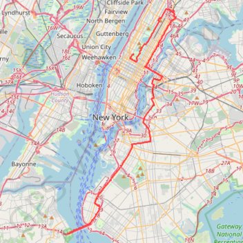
Name: New York City Marathon GPS track, route, trail
End: Warner LeRoy Place, Manhattan, New York County, New York, 10023, United States (40.77269 -73.97667)
Coordinates: 40.60215 -74.05954 40.81479 -73.92439
Other GPS tracks
Click on a GPS track to view route, its statistics and profile.
New
United States > New York > New York County > New York
Distance: 88.5 Km • Elevation gain: 1,435 m • Maximum elevation: 63 m
Liberty State Park
United States > New Jersey > Hudson County > Jersey City > Communipaw
Distance: 7.0 Km • Elevation gain: 16 m • Maximum elevation: 5 m
Central Park Evening walk
United States > New York > New York County > New York
Distance: 3.8 Km • Elevation gain: 69 m • Maximum elevation: 49 m
Forever drawn in by the mystique of Kearny Point
United States > New Jersey > Hudson County > Jersey City
bike ride
Distance: 29.5 Km • Elevation gain: 201 m • Maximum elevation: 35 m
Morning Run
United States > New York > New York County > New York
Distance: 13.7 Km • Elevation gain: 158 m • Maximum elevation: 34 m
Traversée New York
États-Unis d'Amérique > New York > New York
Vélo. En aller simple. #Vélo
Distance: 43.1 Km • Elevation gain: 378 m • Maximum elevation: 43 m
Montréal - New York
Canada > Québec > Agglomération de Montréal > Montréal
Distance: 637.3 Km • Elevation gain: 4,134 m • Maximum elevation: 301 m
Boucle a partir de Houston Station
États-Unis d'Amérique > New York > New York County > New York
Distance: 5.5 Km • Elevation gain: 81 m • Maximum elevation: 41 m